Risk Exploration#
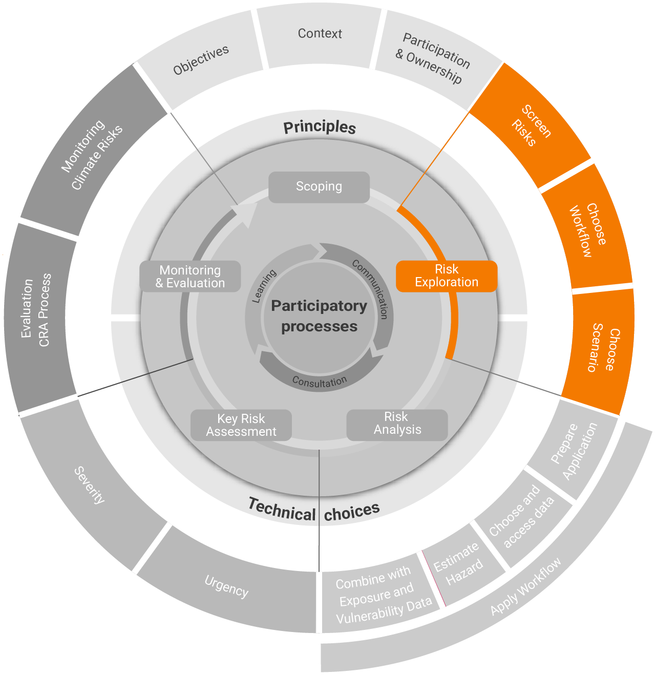
Risk Exploration starts with a broad screening of the risks (their underlying hazards, exposures and vulnerabilities) that are most apparent or of significant concern to key stakeholders and the wider public. A preliminary, rapid analysis of sectors (including activities, supply chains, processes, and infrastructure) and geographic areas at risk (such as ecosystems, landscapes, and communities) can be conducted based on insights from experts and stakeholders.
A deeper dive into the system aspects may highlight affected entities (key systems, elements, sectors, communities, social groups, sub-regions), functions or processes that hold significant value in the local context (e.g. stakeholder interests, community priorities or public agenda). This can reveal (transboundary) connections or dependencies which might be important for evaluating the respective risk outcome. The following subsections will now delve deeper into the screening of risks as well as the selection of workflows and climate scenarios.
Tip
At this stage it’s important to rely as much as possible on factual evidence regarding climate hazards, impacts and risks if available. The focus should especially lie on those hazards that are most likely to result in severe consequences for the region.
Screen Risks#
The primary objective of screening risks is to quickly scrutinize a region’s climate risk context. To do so, it is recommended to use participatory approaches such as consultations with experts, stakeholders and priority groups or also group consultations with all relevant actors. This can be complemented with data-driven methods to gather insights beyond the initial risk considerations from the Scoping step. Where possible, the exploration can dive deeper and cover relevant risk-related aspects, such as affected sectors, spatial extent, and implications across sectors, or regions.
Experts and stakeholders may also take into account participatory input. This can be used to ensure transparency, seek feedback or validate findings, by sharing a summary of key discussion points and risk screening results.
The overall output of the risk screening sub-step is to shortlist risks based on the knowledge and perception of stakeholders and experts while including past and ongoing impacts, expected future changes, and local concerns. Additionally, it helps to highlight areas where additional information, data, or knowledge is needed, thus paving the way for appropriate Risk Workflow selection.
Data Spaces and Hubs
Data spaces and hubs are designed to facilitate data sharing, collaboration, and analysis across different stakeholders and organizations.
The DRMKC Risk Data hub is an extensive tool that explores disaster risk and vulnerability, provides resources in a learning and training space as well as automated access to data.
The IPCC Interactive Atlas is a valuable resource to access and explore observations, reanalyses and observational products. This is a novel tool for flexible spatial and temporal analyses of much of the observed and projected climate change information underpinning the assessment of the physical basis of climate change, including a regional synthesis for the climatic impact-drivers assessed in the report. This product has been extended and incorporated into the Copernicus Climate Change Service (C3S) to become the Copernicus Interactive Climate Atlas (C3S Atlas). It facilitates global and regional in-depth assessment of past trends and future changes in key variables and (extreme) indices for different periods across emission scenarios or for different policy-relevant global warming levels (e.g. 1.5°, 2°, 3° and 4°). Different graphical climate products such as maps and timeseries (or stripes) can be interactively customized to display temporally- or spatially aggregated values (or changes relative to different baselines) over flexible seasons, periods and regions.
Further data spaces and hubs of interest may be: Climate Data Explorer, index-based interactive EEA report, Climate Solutions Explorer, European Drought Impacts Database EDID or PESETA IV.
Tip
The use of maps and visual aids to depict exposure, vulnerability, climate-related hazards, and risks facilitates discussion on the nature and extent of impacts, identifying local risk hotspots, and understanding direct and indirect effects.
Choose Workflow#
The CLIMAAX project offers various risk workflows to conduct a detailed quantitative analysis of climate risks. Following the prioritization of hazards or risks identified in the Screen Risks sub-step, the main goal here is to select the most suitable workflows.
The workflows allow for both a current risk analysis (based on historical data) and the estimation of future risk emerging from climatic shifts (based on future climate change projections). Selecting appropriate workflow(s) is crucial for accurately assessing and understanding the range of possible impacts, facilitating informed decision-making and CRM planning. Therefore, it is highly recommended to include insights from experts, stakeholders, priority groups and decision-makers (that have participated in the Screen Risks sub-step or through other means of participation) to steer the selection of workflow(s) towards an inclusive and needs-based approach.
Tip
One Risk Workflow may have several options (e.g., the floods workflows may analyse flash, river or coastal floods). Make sure you understand the purpose, focus and advantages of each possibility.
Choose Scenario#
Based on the interests and concerns of the regions and their key stakeholders defined in Scoping and further refined in Screen Risks, the objective of this sub-step is to identify relevant future scenarios. Selecting scenarios may range from simple SSP-RCP considerations (Technical Choices) to a more detailed, needs-driven, and decision-focused process considering climate models, downscaling, global warming levels or low-likelihood high-impact events (see Deliverable 1.4). Depending on the workflows, various RCP and coupled SSP-RCP scenarios are available in the workflows to support users in this task, thus ensuring a useful risk analysis.
Choosing a suitable set of scenarios is crucial for the decision-context and policy output and should therefore be discussed with decision-makers. It is advised to formulate a limited number of scenarios that show different challenges.
Simple Scenario Guidance
Scenarios are not predictions; they aim to help strategic thinking and explore possible futures.
Get familiar with the available scenarios. Know their underlying assumptions such as future emissions or socio-economic developments.
Consider your decision maker’s needs, interests or risk aversion.
Be clear on your envisaged time horizon. Most climate scenarios don’t show a difference until 2050 (but vary regarding uncertainty of the model projections).
Selecting a limited number of diverse scenarios is advisable so the level of information and comparability stays manageable while being insightful.